Enhanced Capabilities of the MANUELA 3D/ Rad Scanning Tool for Use at Nuclear Facilities

AUTHORS
Don McGee1, Ernesto Faillace1, John McGehee1, Frédéric Aspe2, Régis Roy2, Stephane Dogny2
1Orano Federal Services, LLC
2Orano DS - Decommissioning Services
PRESENTED
March 2, 2023
Waste Management Symposia
ABSTRACT
Since the initial development and usage of the MANUELATM (Mobile Apparatus for Nuclear Expertise Localization Assistance) 3D gamma mapping instrument, areas of improvement and enhancement have been identified and subsequently incorporated into the instrument. These recent enhancements have greatly expanded the capabilities of the MANUELA survey tool. Lessons Learned from extensive field use have provided the developers with the needed feedback to correct limitation and improve functionality that have resulted in a more robust and versatile 3D scanning/gamma mapping instrument.
MANUELA has been used at numerous nuclear facilities including those in France, United Kingdom, China, and the US. The facilities range from used fuel reprocessing hot cells and nuclear power plants to laboratory environments. This diverse exposure to various environments helped identify the challenges end users encounter when collecting useful data to plan all operations in radiation areas that require comprehensive radiological mapping (e.g., industrial operations, heavy maintenance, D&D activities, etc.). . Based on user inputs from field applications, MANUELA developers have modified different aspects of the instrument including hardware and operating system programing as well as adding more powerful post-processing capabilities to the PoStLAM software.
PoStLAM is the program used to manipulate the data collected by MANUELA. It provides the user with the ability to produce detailed 3D images of the scanned areas with gamma map overlay. It can also be used with Virtual Reality (VR) to provide greater user interaction. Specific enhancements have greatly improved the versatility of the instruments including the ability to mount MANUELA on a telescopic pole for limited-access areas such as vaults, tanks, etc., and to perform scans remotely from a safe environment. In addition, at Orano’s la Hague Recycling facility in France, the instrument was installed on a robotic arm to scan the interior of a hot cell. Improved gamma detectors with a wider detection range have been incorporated to improve performance. Improvements in the 3D scanning function have increased scan efficiency by the user, resulting in faster scan times of high-quality data.
The original driver for the MANUELA system came from licensees’, facility operators’ and decommissioning contractors’ need for comprehensive, accurate and precise radiological and topographical data to plan and execute safe and efficient nuclear projects. Traditional approaches rely greatly upon labor and administratively intensive data collection methods that require considerable time and effort to glean the relevant data to plan and perform work in a radiological work area. Orano DS developed and tested MANUELA at French nuclear facilities where a lightweight portable scanning instrument was needed. Orano conducted demonstrations at US nuclear facilities that have proven to be useful in many areas of the nuclear fuel cycle including:
MANUELA also compiles all the relevant survey data into a downloadable table format which includes the measurement identification number, time stamp, point space location on the XYZ plane, and the dose rate value.
The original driver for the MANUELA system came from licensees’, facility operators’ and decommissioning contractors’ need for comprehensive, accurate and precise radiological and topographical data to plan and execute safe and efficient D&D projects. Traditional approaches rely greatly upon labor and administratively intensive data collection methods that require considerable time and effort to glean the relevant data to plan and perform work in a radiological work area. Orano DS tested MANUELA at French nuclear facilities where a lightweight portable scanning instrument was needed. Orano Federal Services (FS) conducted demonstrations at US nuclear facilities that have proven to be useful in many areas of the nuclear fuel cycle including:
The collection of radiological data mapped onto a 3D image using MANUELA allows the user to use the PoStLAM software to evaluate work areas from an ALARA perspective to better plan work evolutions for access/egress routes, low-dose waiting area and optimal shielding placement. This also applies for decommissioning planning efforts as well. By improved visualization of the nature and extent of the radiological condition of areas to be remediated, work planners can prioritize efforts to improve productivity and effectiveness of decontamination and the subsequent remedial action surveys.
Hardware
The first-generation MANUELA (Fig. 1a) was designed with a fixed (hardwired) GM probe mounted at the top of the device to collect dose rates. An optional Cadmium Zinc Telluride (CZT) probe for collecting gamma spectroscopy data could be mounted on the side and connected to the instrument using a detachable power/data USB connection (with power supplied by the extended tablet battery). The original design presented problems when laying the instrument down due to the possibility of the probe hitting a hard surface and possibly breaking the GM detector or its connection. The GM detector also could not be easily removed from the body of the instrument, resulting in potential maintenance/calibration issues and difficulties in replacing the probe if needed.
The new design solution (Fig. 1b) was to make both probes (GM, CZT) fully detachable and easily replaceable/upgradeable. This allows for much greater flexibility, including possibly adding future low dose rate detection capabilities.
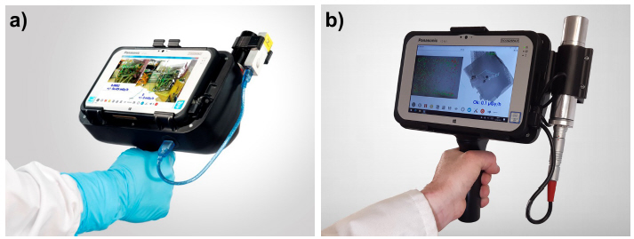
Figure 1. First-generation MANUELA (a) and improved MANUELA (b).
The original gamma probes have been replaced by two new improved sensors (both GM and CZT) that have low energy consumption demands and built-in data loggers that store and transmit the data via USB cable connections to the tablet. Examples of probes that can be attached to MANUELA are Mirion Technologies’ STTC Wide Range Gamma Probe and Kromek GR1TM Compact CZT Spectrometer.
The optical data collection system (comparable to the hardware used in Microsoft’s Xbox KinectTM) has been upgraded to improve the 3D scanning function with higher tolerance for more rapid scans. This has increased scan efficiency by the user, resulting in faster scan times of high-quality data without the data collection gaps that previously occurred in the first-generation hardware.
Software
MANUELA compiles all the relevant survey data into a downloadable table format including the measurement identification number, time stamp, point cloud locations on the XYZ plane, and the associated dose rate values, which can then be viewed directly on the instrument tablet, and post-processed to achieve the full potential of the system.
PoStLAM is the program used to process the data collected by MANUELA. It provides the user with the ability to produce detailed 3D images of the scanned areas with gamma map overlay that can be viewed with Virtual Reality (VR) tools to provide greater user interaction. It could also provide dosimetry calculation as well as radiation localization analysis.
Improvements to the PoStLAM allow the user to merge the point-cloud radiation data generated by MANUELA with much higher-resolution images generated by other systems. An example of such an application are files generated with LiDAR scanning 3D camera systems used to create navigable digital twins of the scanned areas, which can now be imported into PoStLAM. The dose map/image merged files can then be added to a building information model for the facility.
In addition, at Orano’s la Hague Recycling facility in France, the instrument was installed on a robotic arm to scan the interior of a hot cell.
Cell C706 (UP2-400) at la Hague has two different levels: an upper level, which is a relatively accessible zone, with low dose rates and no contamination, and a lower level, providing access to the pits, with higher dose rates and a risk of contamination. Obtaining a radiological map of these lower areas presents a risk to the operators. The proposed solution consisted of a telescopic carbon pole on which MANUELA was installed, adjustable in length from 2 m to 6 m.
This allowed for the radiological mapping of the lower level of the cell without exposing the personnel who remained in the upper level. Scans covering a space of 32 m3 were acquired without difficulty within 5-10 minutes. This resulted in an estimated factor of five dose reduction to the operators compared to the handheld MANUELA. In addition, the telescopic pole allowed the operators to measure contact dose rates while limiting the risk of worker and instrument contamination more easily. Finally, due to the motor-driven device at the end of the pole, the scan resulted in more uniform and higher quality than would have been possible by handheld operation. Fig. 2 shows MANUELA on a telescopic pole, while Fig. 3a and 3b shows the hardware modifications made to the handheld MANUELA to enable tele-scanning. Fig. 4 shows the results from some of the scans performed at la Hague, generated using PoStLAM.
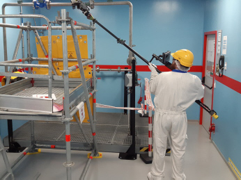
Figure 2. MANUELA mounted on a telescopic pole (tests performed on an Orano’s training site)
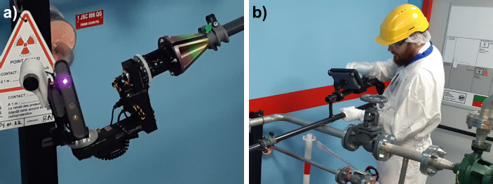
Figure 3. Modifications to MANUELA on a telescopic pole (tests performed on an Orano training site): the motorized device was added at the scanning end of the pole (a) and both the tablet and the motor controls to the base of the pole (b)
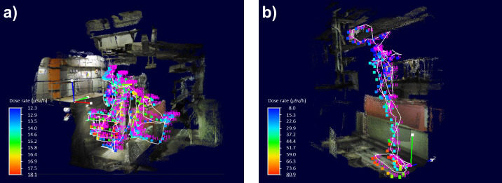
Figure 4. Scans generated at la Hague using MANUELA mounted on a telescopic pole: West balcony, min/max dose rates: 7 to 18 μSv/h (a) and South balcony, min/max dose rates: 15 to 85 μSv/h (b)
This operation was tested and implemented in September 2021 using a remotely operated MANUELA in cell C863 of AD1-BDH facility at la Hague where the maximum dose rate was 110 μSv/h. Three scans of 30 seconds were performed, resulting in about 20 dose rate measurements, and covering 50% of the cell volume. The scans were carried out in parallel with packaging operations. The scans were merged to reproduce the cell in a virtual reality environment improving the management of operations (e.g., for pre-job briefings). Similarly, a radiological mapping of the HA cell C906 of HAO facility at la Hague was performed in 2022.
Fig. 5a and 5b show the 3D-printed mounting hardware used to attach MANUELA (with tablet detached) to the remotely-controlled manipulator arm and the cable connecting the scanner to the tablet. Fig. 6a and 6b show the system tested on a scale model. Fig. 7a and 7b show the results from some of the scans performed at la Hague, generated using PoStLAM.
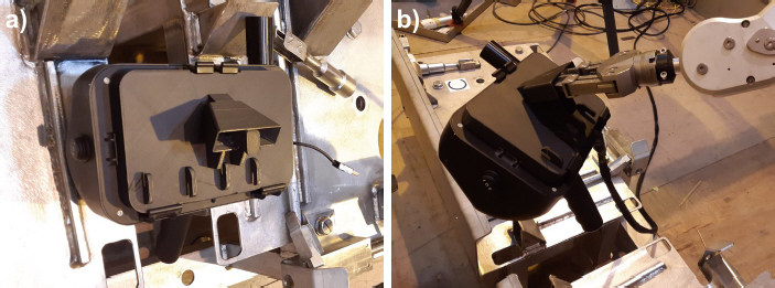
Figure 5. Mount (3D printed) to attach MANUELA (a) to the remotely-controlled manipulator arm (b)
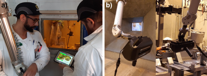
Figure 6. MANUELA system as tested on an Orano’s scale model (a and b).
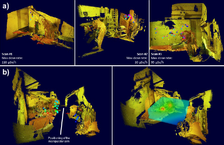
Figure 7. Scans generated using MANUELA mounted on the manipulator arm (a). 3D point cloud model of the C863 cell created by merging the three MANUELA scans (b)
MANUELA also compiles all relevant survey data into a downloadable table format which includes the measurement identification number, time stamp, point space location on the XYZ plane, and the dose rate value for post-processing treatments through PoStLAM software.
During the initial rollout period, several areas of improvement and enhancement were identified and subsequently incorporated into the instrument, greatly expanding the capabilities and reach of the MANUELA survey tool. Lessons Learned from extensive field use provided the developers with the needed feedback to correct limitations and improve functionality that resulting in a more robust and versatile 3D scanning/gamma mapping instrument. These enhancements along with improvements to PoStLAM allow the user greater flexibility and provide a more powerful tool to collect and utilize scanned radiological data.
[2] P. DUBART and M. MORICHI, “3D topographic and radiological modeling of an environment”, STMI, Orano DS Démantèlement et Services, United States Patent, Patent No. US 10733330 B2, 2020.
[3] R. ROY, “3D radiological and topographical mapping”, inTechBrew 3, 2021.
[4] J. MCENTIRE and D. MCGEE, “Use of the Manuela 3D/Radiation scanning tool at Nuclear Facilities – 20437”, WM2020 Conference, March 8-12, 2020, Phoenix, Arizona, USA.
Don McGee1, Ernesto Faillace1, John McGehee1, Frédéric Aspe2, Régis Roy2, Stephane Dogny2
1Orano Federal Services, LLC
2Orano DS - Decommissioning Services
PRESENTED
March 2, 2023
Waste Management Symposia
ABSTRACT
Since the initial development and usage of the MANUELATM (Mobile Apparatus for Nuclear Expertise Localization Assistance) 3D gamma mapping instrument, areas of improvement and enhancement have been identified and subsequently incorporated into the instrument. These recent enhancements have greatly expanded the capabilities of the MANUELA survey tool. Lessons Learned from extensive field use have provided the developers with the needed feedback to correct limitation and improve functionality that have resulted in a more robust and versatile 3D scanning/gamma mapping instrument.
MANUELA has been used at numerous nuclear facilities including those in France, United Kingdom, China, and the US. The facilities range from used fuel reprocessing hot cells and nuclear power plants to laboratory environments. This diverse exposure to various environments helped identify the challenges end users encounter when collecting useful data to plan all operations in radiation areas that require comprehensive radiological mapping (e.g., industrial operations, heavy maintenance, D&D activities, etc.). . Based on user inputs from field applications, MANUELA developers have modified different aspects of the instrument including hardware and operating system programing as well as adding more powerful post-processing capabilities to the PoStLAM software.
PoStLAM is the program used to manipulate the data collected by MANUELA. It provides the user with the ability to produce detailed 3D images of the scanned areas with gamma map overlay. It can also be used with Virtual Reality (VR) to provide greater user interaction. Specific enhancements have greatly improved the versatility of the instruments including the ability to mount MANUELA on a telescopic pole for limited-access areas such as vaults, tanks, etc., and to perform scans remotely from a safe environment. In addition, at Orano’s la Hague Recycling facility in France, the instrument was installed on a robotic arm to scan the interior of a hot cell. Improved gamma detectors with a wider detection range have been incorporated to improve performance. Improvements in the 3D scanning function have increased scan efficiency by the user, resulting in faster scan times of high-quality data.
The original driver for the MANUELA system came from licensees’, facility operators’ and decommissioning contractors’ need for comprehensive, accurate and precise radiological and topographical data to plan and execute safe and efficient nuclear projects. Traditional approaches rely greatly upon labor and administratively intensive data collection methods that require considerable time and effort to glean the relevant data to plan and perform work in a radiological work area. Orano DS developed and tested MANUELA at French nuclear facilities where a lightweight portable scanning instrument was needed. Orano conducted demonstrations at US nuclear facilities that have proven to be useful in many areas of the nuclear fuel cycle including:
- ALARA planning during facility operations
- Scoping and site characterization during the D&D planning phase
- Remedial action support during active decommissioning work
- Final status survey and demonstration of “end state” compliance for license termination
MANUELA also compiles all the relevant survey data into a downloadable table format which includes the measurement identification number, time stamp, point space location on the XYZ plane, and the dose rate value.
INTRODUCTION
MANUELA (Mobile Apparatus for Nuclear Expertise Localization Assistance) is a 3D gamma mapping instrument and analytical system that combines image and point cloud radiation data collection [1]. Once processed, this data can be visualized on a screen or with a VR headset. The system was invented, developed and patented [2] by Orano Dismantling Services (DS), with initial testing and applications performed at French nuclear power plants (e.g., Fessenheim and Cattenom) [3]. MANUELA has subsequently been used at numerous nuclear facilities outside of France (e.g., United Kingdom, China and the United States). The first field demonstrations and applications of MANUELATM in the United States (Nuclear Ship Savannah, Crystal River 3 Nuclear Plant) began in 2018, and the description and initial implementations of the device and system were presented at WM2020 [4].The original driver for the MANUELA system came from licensees’, facility operators’ and decommissioning contractors’ need for comprehensive, accurate and precise radiological and topographical data to plan and execute safe and efficient D&D projects. Traditional approaches rely greatly upon labor and administratively intensive data collection methods that require considerable time and effort to glean the relevant data to plan and perform work in a radiological work area. Orano DS tested MANUELA at French nuclear facilities where a lightweight portable scanning instrument was needed. Orano Federal Services (FS) conducted demonstrations at US nuclear facilities that have proven to be useful in many areas of the nuclear fuel cycle including:
- ALARA planning during facility operations
- Scoping and site characterization during the D&D planning phase
- Remedial action support during active decommissioning work
- Final status survey and demonstration of “end state” compliance for license termination
The collection of radiological data mapped onto a 3D image using MANUELA allows the user to use the PoStLAM software to evaluate work areas from an ALARA perspective to better plan work evolutions for access/egress routes, low-dose waiting area and optimal shielding placement. This also applies for decommissioning planning efforts as well. By improved visualization of the nature and extent of the radiological condition of areas to be remediated, work planners can prioritize efforts to improve productivity and effectiveness of decontamination and the subsequent remedial action surveys.
SYSTEM ENHANCEMENTS
Based on user inputs from field applications, MANUELA developers have modified different aspects of the instrument including hardware (radiation detectors and optics), device operating system programing, and adding more powerful post processing capabilities to the PoStLAM software.Hardware
The first-generation MANUELA (Fig. 1a) was designed with a fixed (hardwired) GM probe mounted at the top of the device to collect dose rates. An optional Cadmium Zinc Telluride (CZT) probe for collecting gamma spectroscopy data could be mounted on the side and connected to the instrument using a detachable power/data USB connection (with power supplied by the extended tablet battery). The original design presented problems when laying the instrument down due to the possibility of the probe hitting a hard surface and possibly breaking the GM detector or its connection. The GM detector also could not be easily removed from the body of the instrument, resulting in potential maintenance/calibration issues and difficulties in replacing the probe if needed.
The new design solution (Fig. 1b) was to make both probes (GM, CZT) fully detachable and easily replaceable/upgradeable. This allows for much greater flexibility, including possibly adding future low dose rate detection capabilities.
The original gamma probes have been replaced by two new improved sensors (both GM and CZT) that have low energy consumption demands and built-in data loggers that store and transmit the data via USB cable connections to the tablet. Examples of probes that can be attached to MANUELA are Mirion Technologies’ STTC Wide Range Gamma Probe and Kromek GR1TM Compact CZT Spectrometer.
The optical data collection system (comparable to the hardware used in Microsoft’s Xbox KinectTM) has been upgraded to improve the 3D scanning function with higher tolerance for more rapid scans. This has increased scan efficiency by the user, resulting in faster scan times of high-quality data without the data collection gaps that previously occurred in the first-generation hardware.
Software
MANUELA compiles all the relevant survey data into a downloadable table format including the measurement identification number, time stamp, point cloud locations on the XYZ plane, and the associated dose rate values, which can then be viewed directly on the instrument tablet, and post-processed to achieve the full potential of the system.
PoStLAM is the program used to process the data collected by MANUELA. It provides the user with the ability to produce detailed 3D images of the scanned areas with gamma map overlay that can be viewed with Virtual Reality (VR) tools to provide greater user interaction. It could also provide dosimetry calculation as well as radiation localization analysis.
Improvements to the PoStLAM allow the user to merge the point-cloud radiation data generated by MANUELA with much higher-resolution images generated by other systems. An example of such an application are files generated with LiDAR scanning 3D camera systems used to create navigable digital twins of the scanned areas, which can now be imported into PoStLAM. The dose map/image merged files can then be added to a building information model for the facility.
MODIFICATIONS FOR REMOTE APPLICATIONS
Specific enhancements have greatly improved the versatility of the instruments, including the ability to mount MANUELA on a telescopic pole for limited-access areas such as vaults, tanks, etc., and to perform scans remotely from a safe environment.In addition, at Orano’s la Hague Recycling facility in France, the instrument was installed on a robotic arm to scan the interior of a hot cell.
MANUELA on a Telescopic Pole
The hand-held MANUELA instrument presents some challenges when attempting to scan elevated, below grade, or other relatively inaccessible locations that are out of reach or dangerous to the worker holding the instrument. This challenge resulted in recommendation from Orano USA engineers to see if the instrument could be mounted on a telescopic pole to increase its reach. The developers identified a location at Orano’s nuclear fuel recycling facility in la Hague where this concept could be tested and implemented in April 2021.Cell C706 (UP2-400) at la Hague has two different levels: an upper level, which is a relatively accessible zone, with low dose rates and no contamination, and a lower level, providing access to the pits, with higher dose rates and a risk of contamination. Obtaining a radiological map of these lower areas presents a risk to the operators. The proposed solution consisted of a telescopic carbon pole on which MANUELA was installed, adjustable in length from 2 m to 6 m.
This allowed for the radiological mapping of the lower level of the cell without exposing the personnel who remained in the upper level. Scans covering a space of 32 m3 were acquired without difficulty within 5-10 minutes. This resulted in an estimated factor of five dose reduction to the operators compared to the handheld MANUELA. In addition, the telescopic pole allowed the operators to measure contact dose rates while limiting the risk of worker and instrument contamination more easily. Finally, due to the motor-driven device at the end of the pole, the scan resulted in more uniform and higher quality than would have been possible by handheld operation. Fig. 2 shows MANUELA on a telescopic pole, while Fig. 3a and 3b shows the hardware modifications made to the handheld MANUELA to enable tele-scanning. Fig. 4 shows the results from some of the scans performed at la Hague, generated using PoStLAM.
MANUELA on a Remote-Controlled Manipulator Arm
In some instances, telescopic poles lack the range or flexibility needed to access hard to reach locations in high radiation areas. Typically, radiological maps of High Activity (HA) cells have been carried out using a SHI type dose rate probe. This probe is installed at the end of a remote-controlled manipulator arm. This operating mode does not always allow complete control of the cells to be investigated, and precise tracking the probe’s position in the measurement space is difficult. A proposed solution to overcome these issues was to install MANUELA on a remotely-controlled manipulator arm. The tablet is remotely operated using a 98 ft long cable. This configuration allows operators to remotely reproduce operator scanning movements and to generate a 3D topographic scan, resulting in an increased density of radiological data during a single operation, and positioning radiation measurements in space with centimeter precision.This operation was tested and implemented in September 2021 using a remotely operated MANUELA in cell C863 of AD1-BDH facility at la Hague where the maximum dose rate was 110 μSv/h. Three scans of 30 seconds were performed, resulting in about 20 dose rate measurements, and covering 50% of the cell volume. The scans were carried out in parallel with packaging operations. The scans were merged to reproduce the cell in a virtual reality environment improving the management of operations (e.g., for pre-job briefings). Similarly, a radiological mapping of the HA cell C906 of HAO facility at la Hague was performed in 2022.
Fig. 5a and 5b show the 3D-printed mounting hardware used to attach MANUELA (with tablet detached) to the remotely-controlled manipulator arm and the cable connecting the scanner to the tablet. Fig. 6a and 6b show the system tested on a scale model. Fig. 7a and 7b show the results from some of the scans performed at la Hague, generated using PoStLAM.
CONCLUSIONS
MANUELA scan data can be used throughout the decommissioning process to validate progress and continue to refine the work activities to optimize the efforts of the crew, which reduces downtime waiting for survey results, whereas traditional survey methodology relies on a physical survey to be performed and the data transcribed onto survey maps that are only two dimensional. The traditional format tends to be inaccurate and difficult to interpret the precise location(s) of hot spots or generalized dose rates.MANUELA also compiles all relevant survey data into a downloadable table format which includes the measurement identification number, time stamp, point space location on the XYZ plane, and the dose rate value for post-processing treatments through PoStLAM software.
During the initial rollout period, several areas of improvement and enhancement were identified and subsequently incorporated into the instrument, greatly expanding the capabilities and reach of the MANUELA survey tool. Lessons Learned from extensive field use provided the developers with the needed feedback to correct limitations and improve functionality that resulting in a more robust and versatile 3D scanning/gamma mapping instrument. These enhancements along with improvements to PoStLAM allow the user greater flexibility and provide a more powerful tool to collect and utilize scanned radiological data.
REFERENCES
[1] F. HAUTOT, P. DUBART, C.-O. BACRI, B. CHAGNEAI and R. ABOU-KHALIL, “Visual Simultaneous Localization and Mapping (VSLAM) methods applied to indoor 3D topographical and radiological mapping in real-time”, EPJ Nuclear Sci. Technol. 3, 15, 2017.[2] P. DUBART and M. MORICHI, “3D topographic and radiological modeling of an environment”, STMI, Orano DS Démantèlement et Services, United States Patent, Patent No. US 10733330 B2, 2020.
[3] R. ROY, “3D radiological and topographical mapping”, inTechBrew 3, 2021.
[4] J. MCENTIRE and D. MCGEE, “Use of the Manuela 3D/Radiation scanning tool at Nuclear Facilities – 20437”, WM2020 Conference, March 8-12, 2020, Phoenix, Arizona, USA.
RESOURCES
MANUELA product flier>> Return to Orano White Papers